
Vehicle-Mounted Weather Stations: Eliminating Vehicle Motion to Calculate True Wind Speed and Direction
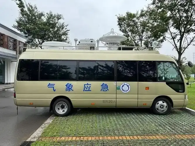
Emergency hazardous material (HAZMAT) response units, mobile incident command trucks, wildfire task forces, and military mobile radar units all rely heavily on localized meteorological data. When a chemical tanker ruptures or a toxic gas leak occurs along a highway corridor, the very first operational question asked by incident commanders is: "Which direction is the plume drifting, and how fast?"
Deploying a mobile weather station on the roof of a rapid-response vehicle allows continuous tracking en route to the incident scene. However, an anemometer mounted to a moving vehicle does not measure the ambient wind; it measures the apparent wind—a dynamic combination of the atmosphere's true wind vector and the vehicle's own ground velocity vector. Learn how our solid-state arrays resolve these dynamic vectors in our mobile and UAV meteorological solutions.
1. Apparent Wind vs. True Wind: The Vector Problem
Consider a patrol vehicle driving directly East ($90^circ$) at a speed of $60 ext{ km/h}$ ($16.67 ext{ m/s}$). If the actual ambient wind is calm ($0 ext{ m/s}$), an uncalibrated vehicle anemometer will register a headwind of $60 ext{ km/h}$ blowing directly from the front ($270^circ$). If an actual ambient wind of $30 ext{ km/h}$ is blowing from the North ($0^circ$), the sensor detects a severe diagonal crosswind.
Mathematically, the apparent wind vector ($ ec{V}_a$) observed by the vehicle-mounted sensor is expressed as:
$$ ec{V}_a = ec{V}_t - ec{V}_v$$
To extract the true environmental wind vector ($ ec{V}_t$), we rearrange the equation:
$$ ec{V}_t = ec{V}_a + ec{V}_v$$
Where:
- $ ec{V}_t$: True ambient wind vector relative to geographic True North.
- $ ec{V}_a$: Apparent wind vector measured by the roof-mounted ultrasonic transducer array.
- $ ec{V}_v$: Ground velocity vector of the moving vehicle (speed over ground and true course over ground).
2. Coordinate Transformations: From Sensor Body Frame to Geographic True North
In real-world mobile deployments, resolving true wind requires synchronizing three coordinate reference systems in real time at 10Hz:
- Sensor Coordinate System (SCS): The physical orientation of the ultrasonic sensor relative to the vehicle's centerline (longitudinal and lateral axes).
- Vehicle Coordinate System (VCS): The dynamic roll ($phi$), pitch ($ heta$), and yaw/heading ($psi$) of the vehicle chassis relative to local horizontal level.
- Geographic Navigation Coordinate System (NED): The Earth-fixed North-East-Down coordinate system oriented to True North.
By decomposing the 2D apparent wind into orthogonal Cartesian components ($u_a, v_a$) and aligning them with the vehicle's GNSS-derived course over ground ($COG$) and speed over ground ($SOG$):
$$u_t = u_a cos(psi) - v_a sin(psi) + V_{ground} sin( heta_{cog})$$
$$v_t = u_a sin(psi) + v_a cos(psi) + V_{ground} cos( heta_{cog})$$
The true wind direction ($WD_t$) and true wind speed ($WS_t$) are then resolved via trigonometry:
$$WS_t = sqrt{u_t^2 + v_t^2}, quad WD_t = left( ext{atan2}(u_t, v_t) imes rac{180}{pi} + 360 ight) pmod{360}$$
3. The Sensor Technology: Why Moving Fleets Need Solid-State Acoustics
Mechanical cup anemometers and wind vanes are physically unusable on moving vehicles. Highway air drag accelerates mechanical bearings beyond their operational design limits, turbulence generated by vehicle roof racks snaps delicate mechanical cups, and physical inertia creates unacceptable time lags during vehicle acceleration and braking.
Solid-state ultrasonic units like the VT-WDC2E Ultrasonic Anemometer utilize acoustic time-of-flight measurements across three orthogonal ultrasonic transducer pairs. With zero moving parts, instantaneous millisecond response rates, integrated electronic magnetic compasses, and low-profile aerodynamic profiles, they survive continuous $120 ext{ km/h}$ highway speeds without calibration drift.
4. Key Operational Scenarios
- HAZMAT Toxic Dispersion Mapping: First responders arriving at chemical spills establish immediate plume dispersion models on their onboard GIS terminals before vehicle engines are even shut down.
- High-Profile Vehicle Rollover Warnings: Highway patrol vehicles continuously transmit crosswind intensity and localized gust profiles to digital overhead signboards, preventing tractor-trailers and camper vans from overturning across exposed suspension bridges.
Conclusion
Vehicle-mounted meteorological monitoring eliminates spatial data voids, converting routine fleet patrols and emergency trucks into dynamic atmospheric observation networks. Speak with our technical specialists to integrate real-time mobile true wind telemetry into your fleet management platforms.